 |  |  |
| Romanian Army in the Second World War · Forum Guidelines |
 Help Help
 Search Search
 Members Members
 Calendar Calendar
|
| Welcome Guest ( Log In | Register ) | Resend Validation Email |

| Pages: (6) 1 [2] 3 4 ... Last » ( Go to first unread post ) |    |
| RHaught |
Posted: November 19, 2004 04:48 am

|
||||
 Sublocotenent Group: Members Posts: 404 Member No.: 93 Joined: August 30, 2003 |
Will try to have it up next weekend. Wife took camera to a conference with her. Have several maps of Romania made by the German armed forces (copied from earlier maps made by Romanian forces). |
||||
  

|
| Dan Andrei |
Posted: December 04, 2004 08:46 pm
|
|
Soldat Group: Members Posts: 1 Member No.: 407 Joined: December 04, 2004 |
Hi all. This is my first post on this forum so .. I would like to apologize for any future mistake I will make .. I still hope I won't do any. I posted here because I think I can help with some info about the Tirgu Frumos area. I lived there for 20 years. First couldn't use the satellite map. Maybe I can't read that map. Anyway Tirgu Frumos is a strategic town. It is completely surrounded by hills. There are 4 main roads from Tirgu Frumos. 1. to the E is the main road to Iasi, the main city of the area, also of the NE Romania. The road crosses some villages near Tirgu Frumos: Razboieni (3-5 km), Baltati (~10km), Sirca(~13-15km), Budai(~25km), Podu Iloaiei, - Iasi(~50km). 2. to SW to Roman(~40km); The nearest village on that road is Strunga (near a forest) (~9km) 3. W to Pascani (~25km, the Siret river crosses E near Pascani from N to S). First village from TF is Ruginoasa (~10km) 4. N to Hirlau (~27km), Botosani (~77km). First village: Boureni(~5km), then Balj (10km), Cotnari (15km) There are some smaller roads connecting some villages near TF: W to Dadesti, Costesti, parallel and N to the Pascani road, also many roads connecting the two roads; N to Cucuteni, W to the Hirlau road; S to Buznea and SE to Oteleni. There is a small river called Bahluiet coming from the north, entering the city on the W side. Then just south from the city and north from the Buznea hill (main hill S to the city) turns E to Podu Iloaiei. The river is very small (3-4 m wide). There is a railroad from E(Iasi, Podu Iloaiei) to W(Pascani) entering Tirgu Frumos S to the Iasi road and N to Bahluiet river and exiting to W south of Pascani road. I don't know almost anything about the TF battle in 1944, but I think I know the area and if anyone would like to ask me something I’ll be happy to help u. P.S. how can you get a satellite map to a area? |

|
| Nucleicacidman |
Posted: December 31, 2004 09:28 pm
|
|
Soldat Group: Members Posts: 3 Member No.: 436 Joined: December 31, 2004 |
David M. Glantz' Forgotten Battles series is very good, I suggest it - that site which was left here was a portion of that book. I used to have my own narrative on the battle, but it seems to have gotten lost, my apologies.
|
|
|
| Carol I |
Posted: March 11, 2005 11:21 pm
|
||
 General de armata Group: Members Posts: 2250 Member No.: 136 Joined: November 06, 2003 |
I have found in Magazin istoric 9/2004 the following fragment by Constantin Isărescu about the events following the battle of Târgu Frumos in May 1944.
|
||
|
|
| Victor |
Posted: March 12, 2005 07:34 am
|
 Admin Group: Admin Posts: 4350 Member No.: 3 Joined: February 11, 2003 |
That action happened about one month after the Soviet offensive in the area of Targu Frumos, that is generally known as the batlle of Tg. Frumos.
|
|
|
| Carol I |
Posted: March 12, 2005 10:32 am
|
||
|
General de armata Group: Members Posts: 2250 Member No.: 136 Joined: November 06, 2003 |
I have already mentioned that the fragment refers to "the events following the battle of Târgu Frumos in May 1944". |
||
|
|
| Florin |
Posted: March 12, 2005 05:24 pm
|
 General de corp de armata Group: Members Posts: 1879 Member No.: 17 Joined: June 22, 2003 |
In www.feldgrau.net, under "Operations and Battles", there are some topics related to Romania. The titles of the topics are:
1. Targul Frumos Battle - May 2 - 4 1944 - Romania http://www.feldgrau.net/phpBB2/viewtopic.php?t=13112 2. Defeat of the Group Army "South Ukraine" in Romania http://www.feldgrau.net/phpBB2/viewtopic.php?t=12713 3. Defense of Iasi-Chisinau 1944 http://www.feldgrau.net/phpBB2/viewtopic.php?t=6831 4. Sewastopol May 1943 http://www.feldgrau.net/phpBB2/viewtopic.php?t=10897 |
|
|
| RHaught |
Posted: March 16, 2005 02:09 am
|
|
Sublocotenent Group: Members Posts: 404 Member No.: 93 Joined: August 30, 2003 |
Ok, sorry for being away for so long! Will try to post maps on Saturday if possible (can take pics but still can't figure out how to download onto these postings). Have about 20 maps of Romania. Florin has seen some of them when he came to Philly!
Florin, got your emails but have been busy! Preparing to move to NYC in 3 months. Will respond shortly! |
|
|
| Florin |
Posted: March 19, 2005 02:38 am
|
|
General de corp de armata Group: Members Posts: 1879 Member No.: 17 Joined: June 22, 2003 |
Rob,
I remember the size (the papers) are quite big. If you want to get a whole map in a photo, and then to reduce the number of pixels to fit here, I am afraid the text will not be readable. (I forgot the size of the text on the maps.) You can do what Dragos did under another topic: to divide the information. A regular scanner is designed for the American A size (and for its German / DIN equivalent A4). Keeping the map above the scanner (of course, you have to keep the lid completely open) will allow you to scan parts of it, and then to show them here, one per each post. A resolution of 72 points per inch should be sufficient, and avoid to save in "TIFF" or "bitmap". JPG is quite good for what we need here. Otherwise, your files will not fit in the 200 kB limit, which is a must for this site. If the text on the maps is big, making photos with a digital camera may be a reasonable idea. But again, they have to fit in the 200 kB limit. Success and regards! I am glad to hear you'll move to NYC. And considering that you have to move in 3 weeks from now, some delay in posting the maps here will be fully understood. P.S.: "Philly", from Rob's message, means Philadelphia, Pennsylvania. This post has been edited by Florin on March 19, 2005 02:56 am |
|
|
| Carol I |
Posted: March 20, 2005 09:13 pm
|
||
|
General de armata Group: Members Posts: 2250 Member No.: 136 Joined: November 06, 2003 |
Here are some images from the area around Târgu Frumos taken through the windshield of a moving car. Hill line south of the Târgu Frumos-Podu Iloaiei highway Attached Image  |
||
|
|
| Carol I |
Posted: March 20, 2005 09:14 pm
|
|
General de armata Group: Members Posts: 2250 Member No.: 136 Joined: November 06, 2003 |
Hill line south of the Târgu Frumos-Podu Iloaiei highway
Attached Image  |
|
|
| Carol I |
Posted: March 20, 2005 09:15 pm
|
|
General de armata Group: Members Posts: 2250 Member No.: 136 Joined: November 06, 2003 |
Hill line south of the Târgu Frumos-Podu Iloaiei highway
Attached Image 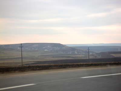 |
|
|
| Carol I |
Posted: March 20, 2005 09:15 pm
|
|
General de armata Group: Members Posts: 2250 Member No.: 136 Joined: November 06, 2003 |
Eastern approach to Târgu Frumos
Attached Image  |
|
|
| Carol I |
Posted: March 20, 2005 09:18 pm
|
|
General de armata Group: Members Posts: 2250 Member No.: 136 Joined: November 06, 2003 |
Terrain north of the Târgu Frumos-Podu Iloaiei highway
Attached Image  |
|
|
| Carol I |
Posted: March 20, 2005 09:20 pm
|
|
General de armata Group: Members Posts: 2250 Member No.: 136 Joined: November 06, 2003 |
|
|
|

1 User(s) are reading this topic (1 Guests and 0 Anonymous Users)
0 Members:
 Pages: (6) 1 [2] 3 4 ... Last »
 |
|
[ Script Execution time: 0.0530 ] [ 14 queries used ] [ GZIP Enabled ]
Powered by Invision Power Board(U) v1.3.1 Final © 2003 IPS, Inc.